


Shapefile over Map (Demo)
Shapefile over Map (Demo)의 설명
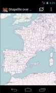
Load your own shapefiles with this Geographic Information System (GIS) directly from the sdcard of your mobile device and visualize them over a map. You can also edit the values of its dbf table and use it in offline mode, loading maps from your memory card.
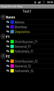
With this GIS application, you can select and load a shp file or load an entire folder automatically.
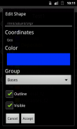
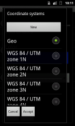
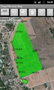
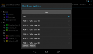
You can select one of these shp files and mark it as the active layer and if you do a long press over one of them you can change its coordinate system, its color or make it invisible.
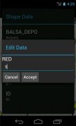
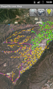
The map will display a series of icons, belonging to each of the records in the active layer, which when pressed will allow you to view and edit information from its corresponding attribute table.
The application also allows you to view your current position via GPS and center the map on it.
You can choose between several online map servers.
This is a demo version, some functionalities are only available in the full version.
Load your own shapefiles with this Geographic Information System (GIS) directly from the sdcard of your mobile device and visualize them over a map. You can also edit the values of its dbf table and use it in offline mode, loading maps from your memory card.
With this GIS application, you can select and load a shp file or load an entire folder automatically.
You can select one of these shp files and mark it as the active layer and if you do a long press over one of them you can change its coordinate system, its color or make it invisible.
The map will display a series of icons, belonging to each of the records in the active layer, which when pressed will allow you to view and edit information from its corresponding attribute table.
The application also allows you to view your current position via GPS and center the map on it.
You can choose between several online map servers.
This is a demo version, some functionalities are only available in the full version.
Shapefile over Map (Demo) - 버전 3.1
(28-03-2018)Shapefile over Map (Demo) - APK 정보
APK 버전: 3.1패키지: com.dabebro.somdemoShapefile over Map (Demo)의 최신 버전


동일 카테고리의 앱


좋아할 만한 것...


